See the world
a bit
differently
AN INSIGHT INTO DRONES
a bit
AN INSIGHT INTO DRONES


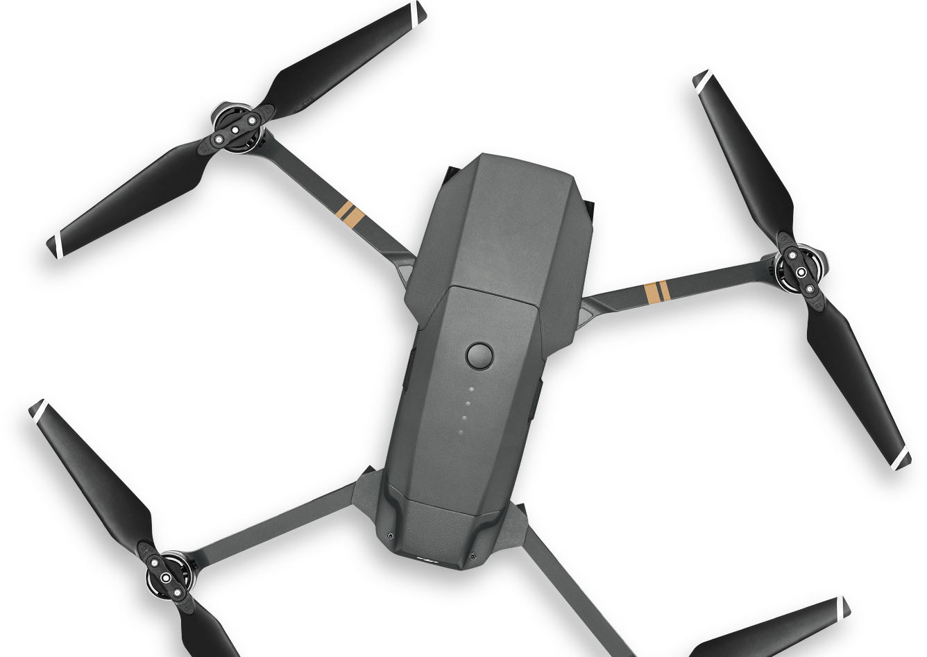
The term drone usually refers to any unpiloted aircraft. Sometimes referred to as unmanned
aerial vehicles (UAVs),
these crafts can carry out an impressive range of tasks, ranging
from military operations to package delivery.

Drones, sometimes referred to as unmanned aerial vehicles (UAVs), carry out
tasks that range from the mundane
to the ultra-dangerous. These robot-like
aircrafts can be found rescuing avalanche victims as well as dropping off
groceries at your doorstep
— and almost everywhere in between.
A drone refers to any aerial vehicle that receives remote commands from a pilot or
relies on software
for autonomous flight.Many drones display features like cameras
for collecting visual data and propellers for stabilizing their flight
patterns. Sectors
like videography, search and rescue, agriculture and transportation have adopted
drone technology.
Originally developed for the military and aerospace industries, drones have
found their way into the mainstream because
of the enhanced levels of safety
and it's efficiency they bring. These robotic UAVs operate without a pilot on
board and with different levels of autonomy.
A drone's autonomy level can range from remotely piloted (a human controls
its movements) to advanced autonomy, which means that it relies on a system
of sensors and LiDAR detectors to calculate its movement.
Different drones are capable of traveling varying heights and distances. Very
close-range drones usually have
the ability to travel up to three miles and are
mostly used by hobbyists. Close-range UAVs have a range of around 30 miles.
Short-range drones travel up to 90 miles and are used primarily
for espionage
and intelligence gathering. Mid-range UAVs have a 400-mile distance range
and could be used for intelligence gathering, scientific studies and alos
meteorological research. The
longest-range drones are called “endurance”
UAVs and have the ability to go beyond the 400-mile range and up to 3,000
feet in the air.
Because drones can be controlled remotely and can be flown at varying
distances and heights, they make
perfect candidates to take on some of the
toughest jobs in the world. They can be found assisting in a search for
survivors after
a hurricane, giving law enforcement and military an eye-in
-the-sky during terrorist situations and advancing scientific research in
some
of the most extreme climates on the planet. Drones have even made their
way into our homes and serve as entertainment for hobbyists
and a vital
tool for photographers.
Many parts are involved behind the scenes to support the seamless operation
of drones, so it's important to
become familiar with the unmanned or remote
technology that makes up a drone's system. From delivering commands to
ensuring a manageable
weight, pilots must take into account the various
factors that make a drone suited for specific jobs. Among the many variables
in play,
some of the most critical components of a drone to consider are its
ground control station (GCS), payload and data links.
Drones rely on a combination of hardware and software components to achieve
successful takeoff, flight and
landing. Drones are often equipped with rotors or fixed
wings, sensors, navigation systems and gyroscopes (for stability), and are
operated
by ground control stations.
Drones are commonly referred to as Unmanned Aerial Vehicles (UAV),
whereas the entire system that allows a
drone to function is a UAS (Unmanned
Aerial System.) The UAV is the heart of the UAS and possesses fixed wings
or either a single or
multi-rotary build for flight. Lighter-than-air UAVs, such
as blimps and balloons, and small “Flapping Wing” UAVs also exist.
Another name for drones is unmanned aerial vehicle (UAV), which is an aircraft that doesn't require a pilot
to be physically onboard. UAVs are often separated into two categories — civilian and military. While civilian UAVs are used for package
deliveries and recreation, military drones are used for reconnaissance missions and
carrying out offensive strikes on enemy targets.
Ground Control Stations are the central control unit that allows a UAV to fly
and a UAS to operate.
These stations can be as large as a desk with multiple
views to as small as a handheld controller or even an app. The GCS can
be
user controlled or operated via satellites and is capable of controlling flight,
controlling payload sensors, providing
status readouts, mission planning and
tethering the data link system.
Drones, UAVs specifically, come in a variety of sizes and are capable of
carrying payloads of equally
variable sized payloads. From life-saving
medication to packages and more, drones provide an efficient method of
delivery but must
be built to handle the job at hand. Many drones are capable
of rapid flight across oceans while others may be restricted to just
a few
thousand feet. Some drones may be capable of carrying hundreds of pounds
while others can only manage under ten. It is
crucial for operators to choose the
right drone to help them complete the job at hand.
Data Links act as the transmission center that allow the drone to communicate
with the ground operator while
in flight. Typically utilizing radio frequency
technology to communicate, the data link provides the operator with crucial data
like
remaining flight time, distance from the operator, distance from target,
airspeed altitude and more. UAV control at 2.4 GHz for control
and 5 GHz for
video will provide the operator with approximately four miles of usability, while
frequencies of 900 MHz for flight
control and 1.3 GHz for video control can
provide more than 20 miles of usability — adding to the list of reasons why pilots
must
use the right UAS for the task they mean to achieve.
Drones depend on a number of parts working together in order to complete tasks
under changing conditions. While
gyroscopes and vertical take-off and landing
(VTOL) capabilities make it easier to remotely control drones, GPS and LiDAR
technology
instill drones with a strong sense of direction. It takes all of these pieces
to create a functioning drone that has the capacity to scan
its surroundings while
enduring a range of environments.
Many drones, typically multi-rotor drones, are considered Vertical Take-off and
Landing (VTOL) drones due to their
ability to take off, fly, hover and land in a
vertical position.
Found in numerous types of drones, dual Global Navigation Satellite Systems
(GNSS) like GPS and GLONASS drones are able
to operate in both non-satellite
and satellite modes, providing enhanced connectivity during operation.
GNSS allows Return to Home safety technology to function on a drone and can
be activated through the ground station's remote controller.
This allows pilots to
be informed as to whether there are enough drone GNSS satellites available for
the drone to be flown independently,
the current location of the drone compared
to the pilot and the “home point” for the drone to return to. In addition to being
controllable
through the controller, Return to Home can also be automatically
activated once the battery is low or when loss of contact between the
drone and
the controller occurs.
Gyroscopes consist of a wheel that can spin in any direction on its axis and are
used in drones to measure the rate
of rotation. Because a gyroscope focuses on
the tilt of a drone, it becomes essential for providing stability. This way, drones
can maintain
their direction and deliver a smooth flying experience.
Drones come in a variety of types, each tailored to the unique demands of
different industries. For instance, some people require
lightweight drones to
hold a camera for photography, while others need robust drones to transport
heavy medical supplies. As a
result, companies produce drones that come in
four main types — single-rotor helicopter, multi-rotor, fixed-wing and fixed-
wing
hybrid VTOL.
Single-rotor helicopters look like tiny helicopters and can be gas or electric-
powered. The single blade and ability to run on gas
help its stability and fly
for longer distances. These UAVs are usually used to transport heavier
objects, including LiDAR systems,
that can be used to survey land, research
storms and map erosion caused by global warming.
The stamina of single-rotor drones makes them a popular choice, especially
when powered by a gas engine. A single, larger blade is what
makes these
drones much more efficient during flight, allowing them to outperform their
multi-rotor counterparts. As a result, many
pilots rely on single-rotor
helicopter drones to carry more weight.
Multi-rotor drones still lack the endurance and payload capacity seen in single-
rotor helicopter drones. A pilot would be lucky to keep a
multi-rotor drone in the
air for over 30 minutes. And while these drones are easier to fly, they become
unstable in windy conditions and
can't stray too far from their controller.
Multi-rotor drones are usually some of the smallest and lightest drones on the
market. They have limited distance, speed and height, but make the
perfect
flying vehicle for enthusiasts and aerial photographers. These drones can usually
spend 20-30 minutes in the air carrying a lightweight
payload, such as a camera.
Multi-rotor drones are probably the most accessible drones available to the
public, since they are easy to control and maneuver during flight.
Some multi
-rotor drones are ideal for beginner pilots as well, leading to them being an
affordable option in the drone market.
Multi-rotor drones still lack the endurance and payload capacity seen in single
-rotor helicopter drones. A pilot would be lucky to keep a
multi-rotor drone in the
air for over 30 minutes. And while these drones are easier to fly, they become
unstable in windy conditions and can't
stray too far from their controller.
Fixed-wing drones look like normal airplanes, where the wings provide the lift
instead of rotors- making them very efficient. These drones
usually use fuel
instead of electricity, allowing them to glide in the air for more than 16 hours.
Since these drones are usually much larger,
and because of their design, they
need to take off and land on runways just as airplanes do. Fixed-wing UAVs are
used by the military to carry
out strikes, by scientists to carry large amounts of
equipment and even by nonprofits to deliver food and other goods to areas that
are hard
to reach.
Fixed-wing drones are durable and can cover longer distances and carry heavier
objects than other drones. Their sturdy frame also enables them
to withstand
windier conditions, remaining steady while maintaining a swift travel speed.
Because fixed-wing drones cannot hover and must be moving forward at all times,
they are much more difficult to land than other drones. They need
plenty of space
to take off and touch down, just like regular airplanes. As a result, fixed-wing
drones require extensive training and reside on
the higher end of the price spectrum.
Fixed-wing hybrid VTOL drones are a blend of fixed-wing drones and rotor
-based drones, featuring rotors that are attached to the
wings. Due to its hybrid
approach, this technology offers users the endurance of a fixed-wing design and
the vertical flying
capabilities of a rotor-focused design. Companies take
advantage of this combination, relying on fixed-wing hybrid VTOL drones
to
further cut down on delivery times while offering a more versatile flight
experience.
Fixed-wing hybrid VTOL drones have the stamina needed to travel long distances,
even while handling heftier payloads. They also
have the ability to fly vertically and
hover, offering more versatility than fixed-wing drones.
Fixed-wing hybrid VTOL drones operate as a jack of all trades, performing many
tasks while not specializing in any area. In
other words, they can fly forward and
hover, but they're not great at either. Pilots also need training to fly these drones
and must be willing to pay more for them. This technology is new and still
developing, so more flaws could arise as the industry
continues to experiment with
fixed-wing hybrid VTOL drones.
Drones are used for more than military and recreational purposes. In fact, UAVs
can be found improving the efficiency and safety of
almost every industry
imaginable, from wildlife conservation to medical supply delivery.
Probably the oldest, most well-known and controversial use of drones is in the
military. The British and U.S. militaries started using
very basic forms of
drones in the early 1940s to spy on the Axis powers. Today's drones are much
more advanced than the UAVs of yesteryear,
equipped with thermal imaging,
laser range finders and even tools to perform airstrikes. One of the most
prominent military drones in use
today is the MQ-9 Reaper. The aircraft
measures 36 feet long, can fly 50,000 feet in the air undetected and is equipped
with a combination
of missiles and intelligence gathering tools.
Delivery drones are typically autonomous UAVs used to transport food,
packages or goods to your front doorstep. These flying vehicles are known
as
“last mile” delivery drones because they are used to make deliveries from stores
or warehouses close by. Retailers and grocery chains all over
the country are
turning to drones as a more efficient delivery alternative, instead of relying on
delivery drivers with inefficient trucks.
These drones can carry 55 pounds of
goods to your front door without you ever having to leave the house. Amazon,
Walmart, Google, FedEx, UPS
and many other big brands are all testing out
different versions of delivery drones.
Sometimes it's not safe enough to send humans into a rescue situation, due to
the scope or severity of the disaster. That's where drones come in.
In the case of
a capsized boat or drowning individual, officials can throw an Autonomous
Underwater Vehicle (AUV) into the water to assist in the
rescue. If there's an
avalanche, drones are deployed to look for those caught in the snow. Aircraft
maker, Kaman, has even developed a
pilotless helicopter, called the K-MAX,
designed to carry more than 6,000 pounds of cargo. The K-MAX has already
been used in China and
Australia to assist in fighting fires.
Drones have proven to be beneficial to the agriculture industry as well,
presenting farmers with several ways to optimize their farms to maximize
efficiency and reduce physical strain. Carrying out field surveys, seeding
over fields, tracking livestock and estimating crop yield are all
made easier
through the use of UAVs while saving agriculture professionals valuable time.
NASA and the U.S. Air Force have been secretly testing out unmanned
aircraft geared towards space travel. The X-37B UAV is the Air Force's
ultra
-secretive drone that looks like a miniature space shuttle. It has been quietly
circling the Earth for the last two years, setting a
record for longest flight
from an unmanned aircraft (781 days and counting). Although vague, the Air
Force has said “the primary objectives
to the X-37B are twofold: reusable
spacecraft technologies for America's future in space and operating
experiments which can be returned
to, and examined, on Earth.” It seems that
drones have been made a priority when it comes to the future of space
exploration and innovation.
Drones are a cheaper and more efficient alternative to wildlife conservation.
Tracking wildlife populations is nearly impossible with humans on the ground.
Having an eye-in-the-sky allows wildlife conservationists to track roaming
groups of animals, ranging from Orangutans in Borneo to Bison on the Great
Plains, to get a better idea of the health of their species and ecosystems.
Conservation drones also make perfect tools in the fight against poaching
efforts in Asia and Africa.
Drones are also being used for reforestation efforts all over the world. These
drones scour the forest floors of forests decimated by fires and
drop seed vessels
filled with seeds, fertilizers and nutrients that will help a tree rise from the ashes.
There have been around 300 million
acres of deforested land since the early
1990s. What would take humans around 300 years to reforest can be more
efficiently completed via
seed-planting drone technology.
Finally, UAVs are becoming instrumental in historical conservation efforts.
Drones are being used to map out 3D renderings of historical sites like
Chernobyl,
the ancient Greek sites of Ephesus, Turkey and Jewish cemeteries
all over Europe. The vantage point gives historical preservationists the ability
to find
clues about culture and architecture while using 3D imagery to recreate
lost sites.
How do you get medical supplies to people in hard-to-reach areas? What tool
could you use to deliver organs for transplant patients? Drones are the answer
to both
of those questions. Right now, unmanned aerial vehicles are being
used to deliver emergency medical supplies and cargo to off-the-grid
communities in rural Alaska.
Instead of relying on dog sleds, snowmobiles or
ambulances that can't handle snow, Alaskans are relying on drones to quickly
receive life-saving medical supplies.
Drones are also being tapped to deliver donated organs to transplant patients.
Just recently, history was made when a kidney was transported by a specially
-made drone from
one hospital in Maryland to the next in just under five
minutes. This could cut down on the alarmingly slow rate at which donations
usually arrive (if they arrive at all).
Usually, organs are delivered via chartered
or commercial flights. Delays and lapses in judgment cause dangerous delays
of two hours or more for 4 percent of all organ
deliveries. Drones can cut time
down tremendously while offering a safer and secure method of organ
transportation.
LiDAR drones come outfitted with LiDAR sensors, which survey landscapes
and compile in-depth data that can be used to build 3D models.
Drones
equipped with LiDAR can present far more accurate data than drones without
the technology. Besides making it easier to navigate
various surfaces, LiDAR
enables drones to spot targets in search and rescue missions, evaluate crops in
agriculture and more.
Drones have been a boon for photographers who use UAVs to take expansive
aerial photos. Ever wonder what it's like to get a bird's eye view of your
favorite city,
beach or building? There are drones made specifically for
photography that provide a new way to photograph some of your favorite
destinations from above.
Up until 2016, commercial businesses that utilized drone technology were
required to possess a pilot's license regardless of their industry.
However, new
government regulations have come into play that require those piloting drones
for commercial purposes to earn a Remote Pilot
Certificate by taking an
aeronautical knowledge test. The exam consists of 60 multiple-choice
questions, with topics including regulations
to Unmanned Aerial System (UAS)
rating privileges, limitations and flight operation, effects of weather on UAS
performance, emergency
procedures, airport regulations, decision making,
maintenance and more. To be eligible to take the exam, one must be at least 16
years old,
be able to read, understand, speak and write English, and be in good
enough physical and mental condition to fly a drone.
Drones present several solutions to emerging and lingering challenges throughout
industries. However, many have expressed concern over the
potential negative
impact that the growth of these devices presents.
Because drones rely on cameras to operate, which often allow operators to take
photos and record videos, many have shown discontent at being
captured without
their consent. Several laws exist to restrict drones from intruding too far on others
privacy, but many users choose to
ignore these laws.
Whether in the air or on the ground, all human-operated aircraft possess an
inherent risk of crashing — even when they are unmanned. Drones
operate on
limited battery power at a time, possess propellers that spin quickly to provide lift
and have the potential to fall from great
heights, posing a large risk to people,
property and the environment as the number of drones in use scales upward.
As drones become more popular in everyday and military use, they become a
bigger target for cyber attacks. Hackers can feed false GPS coordinates
to take
control of a drone, and they can even intercept data that is transmitted between
a drone and its remote controller. People should take
extra precautions to protect
drones and the information they store, such as implementing anti-virus software,
adopting firmware patches and using strong passwords.